GLOBAL POSITIONING SYSTEM (GPS)
What is GPS?
The Global Positioning System (GPS) is a location system based on a constellation of about 24 satellites orbiting the earth at altitudes of approximately 11,000 miles. GPS was developed by the United States Department of Defense (DOD), for its tremendous application as a military locating utility. The DOD's investment in GPS is immense. Billions and billions of dollars have been invested in creating this technology for military uses. However, over the past several years, GPS has proven to be a useful tool in non-military mapping applications as well.
GPS satellites are orbited high enough to avoid the problems associated with land based systems, yet can provide accurate positioning 24 hours a day, anywhere in the world. Uncorrected positions determined from GPS satellite signals produce accuracies in the range of 50 to 100 meters. When using a technique called differential correction, users can get positions accurate to within 5 meters or less.
Today, many industries are leveraging off the DOD's massive undertaking. As GPS units are becoming smaller and less expensive, there are an expanding number of applications for GPS. In transportation applications, GPS assists pilots and drivers in pinpointing their locations and avoiding collisions. Farmers can use GPS to guide equipment and control accurate distribution of fertilizers and other chemicals. Recreationally, GPS is used for providing accurate locations and as a navigation tool for hikers, hunters and boaters.
Many would argue that GPS has found its greatest utility in the field of Geographic Information Systems (GIS). With some consideration for error, GPS can provide any point on earth with a unique address (its precise location). A GIS is basically a descriptive database of the earth (or a specific part of the earth). GPS tells you that you are at point X,Y,Z while GIS tells you that X,Y,Z is an oak tree, or a spot in a stream with a pH level of 5.4. GPS tells us the "where". GIS tells us the "what". GPS/GIS is reshaping the way we locate, organize, analyze and map our resources.
Trilateration - How GPS Determines Location
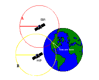
In a nutshell, GPS is based on satellite ranging - calculating the distances between the receiver and the position of 3 or more satellites (4 or more if elevation is desired) and then applying some good old mathematics. Assuming the positions of the satellites are known, the location of the receiver can be calculated by determining the distance from each of the satellites to the receiver. GPS takes these 3 or more known references and measured distances and "triangulates" an additional position.
As an example, assume that I have asked you to find me at a stationary position based upon a few clues which I am willing to give you. First, I tell you that I am exactly 10 miles away from your house. You would know I am somewhere on the perimeter of a sphere that has an origin as your house and a radius of 10 miles. With this information alone, you would have a difficult time to find me since there are an infinite number of locations on the perimeter of that sphere.
Second, I tell you that I am also exactly 12 miles away from the ABC Grocery Store. Now you can define a second sphere with its origin at the store and a radius of 12 miles. You know that I am located somewhere in the space where the perimeters of these two spheres intersect - but there are still many possibilities to define my location.
Adding additional spheres will further reduce the number of possible locations. In fact, a third origin and distance (I tell you am 8 miles away from the City Clock) narrows my position down to just 2 points. By adding one more sphere, you can pinpoint my exact location. Actually, the 4th sphere may not be necessary. One of the possibilities may not make sense, and therefore can be eliminated.
For example, if you know I am above sea level, you can reject a point that has negative elevation. Mathematics and computers allow us to determine the correct point with only 3 satellites.
Based on this example, you can see that you need to know the following information in order to compute your position:
A) What is the precise location of three or more known points (GPS satellites)?
B) What is the distance between the known points and the position of the GPS receiver?
How the Current Locations of GPS Satellites are Determined
GPS satellites are orbiting the Earth at an altitude of 11,000 miles. The DOD can predict the paths of the satellites vs. time with great accuracy. Furthermore, the satellites can be periodically adjusted by huge land-based radar systems. Therefore, the orbits, and thus the locations of the satellites, are known in advance. Today's GPS receivers store this orbit information for all of the GPS satellites in what is known as an almanac. Think of the almanac as a "bus schedule" advising you of where each satellite will be at a particular time. Each GPS satellite continually broadcasts the almanac. Your GPS receiver will automatically collect this information and store it for future reference.
The Department of Defense constantly monitors the orbit of the satellites looking for deviations from predicted values. Any deviations (caused by natural atmospheric phenomenon such as gravity), are known as ephemeris errors. When ephemeris errors are determined to exist for a satellite, the errors are sent back up to that satellite, which in turn broadcasts the errors as part of the standard message, supplying this information to the GPS receivers.
By using the information from the almanac in conjuction with the ephemeris error data, the position of a GPS satellite can be very precisely determined for a given time.
Computing the Distance Between Your Position and the GPS Satellites
GPS determines distance between a GPS satellite and a GPS receiver by measuring the amount of time it takes a radio signal (the GPS signal) to travel from the satellite to the receiver. Radio waves travel at the speed of light, which is about 186,000 miles per second. So, if the amount of time it takes for the signal to travel from the satellite to the receiver is known, the distance from the satellite to the receiver (distance = speed x time) can be determined. If the exact time when the signal was transmitted and the exact time when it was received are known, the signal's travel time can be determined.
In order to do this, the satellites and the receivers use very accurate clocks which are synchronized so that they generate the same code at exactly the same time. The code received from the satellite can be compared with the code generated by the receiver. By comparing the codes, the time difference between when the satellite generated the code and when the receiver generated the code can be determined. This interval is the travel time of the code. Multiplying this travel time, in seconds, by 186,000 miles per second gives the distance from the receiver position to the satellite in miles.
Four (4) Satellites to give a 3D
position
In the previous example, you saw that it took only 3 measurements to "triangulate" a 3D position. However, GPS needs a 4th satellite to provide a 3D position. Why??
Three measurements can be used to locate a point, assuming the GPS receiver and satellite clocks are precisely and continually synchronized, thereby allowing the distance calculations to be accurately determined. Unfortunately, it is impossible to synchronize these two clocks, since the clocks in GPS receivers are not as accurate as the very precise and expensive atomic clocks in the satellites. The GPS signals travel from the satellite to the receiver very fast, so if the two clocks are off by only a small fraction, the determined position data may be considerably distorted.
The atomic clocks aboard the satellites maintain their time to a very high degree of accuracy. However, there will always be a slight variation in clock rates from satellite to satellite. Close monitoring of the clock of each satellite from the ground permits the control station to insert a message in the signal of each satellite which precisely describes the drift rate of that satellite's clock. The insertion of the drift rate effectively synchronizes all of the GPS satellite clocks.
The same procedure cannot be applied to the clock in a GPS receiver। Therefore, a fourth variable (in addition to x, y and z), time, must be determined in order to calculate a precise location. Mathematically, to solve for four unknowns (x,y,z, and t), there must be four equations. In determining GPS positions, the four equations are represented by signals from four different satellites.
GPS Error Budget
The GPS system has been designed to be as nearly accurate as possible. However, there are still errors. Added together, these errors can cause a deviation of +/- 50 -100 meters from the actual GPS receiver position. There are several sources for these errors, the most significant of which are discussed below:
Atmospheric Conditions
The ionosphere and troposphere both refract the GPS signals. This causes the speed of the GPS signal in the ionosphere and troposphere to be different from the speed of the GPS signal in space. Therefore, the distance calculated from "Signal Speed x Time" will be different for the portion of the GPS signal path that passes through the ionosphere and troposphere and for the portion that passes through space.
Ephemeris Errors/Clock Drift/Measurement Noise
As mentioned earlier, GPS signals contain information about ephemeris (orbital position) errors, and about the rate of clock drift for the broadcasting satellite. The data concerning ephemeris errors may not exactly model the true satellite motion or the exact rate of clock drift. Distortion of the signal by measurement noise can further increase positional error. The disparity in ephemeris data can introduce 1-5 meters of positional error, clock drift disparity can introduce 0-1.5 meters of positional error and measurement noise can introduce 0-10 meters of positional error.
Selective Availability
Ephemeris errors should not be confused with Selective Availability (SA), which is the intentional alteration of the time and epherimis signal by the Department of Defense. SA can introduce 0-70 meters of positional error. Fortunately, positional errors caused by SA can be removed by differential correction.
Multipath
A GPS signal bouncing off a reflective surface prior to reaching the GPS receiver antenna is referred to as multipath. Because it is difficult to completely correct multipath error, even in high precision GPS units, multipath error is a serious concern to the GPS user.
The chart below lists the most common sources of error in GPS positions. This chart is commonly known as the GPS Error Budget:
GPS Error Budget
Source   Uncorrected Error Level
Ionosphere  0-30 meters
Troposphere  0-30 meters
Measurement Noise 0-10 meters
Ephemeris Data  1-5 meters
Clock Drift  0-1.5 meters
Multipath  0-1 meter
Selective Availability 0-70 meters
Measuring GPS Accuracy
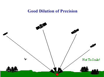
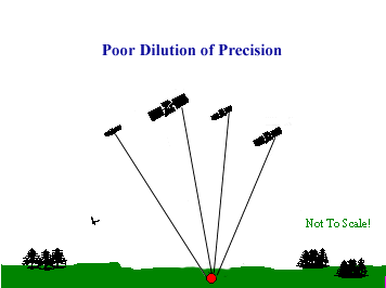
As discussed above, there are several external sources which introduce errors into a GPS position. While the errors discussed above always affect accuracy, another major factor in determining positional accuracy is the alignment, or geometry, of the group of satellites (constellation) from which signals are being received. The geometry of the constellation is evaluated for several factors, all of which fall into the category of Dilution Of Precision, or DOP.
DOP
DOP is an indicator of the quality of the geometry of the satellite constellation. Your computed position can vary depending on which satellites you use for the measurement. Different satellite geometries can magnify or lessen the errors in the error budget described above. A greater angle between the satellites lowers the DOP, and provides a better measurement. A higher DOP indicates poor satellite geometry, and an inferior measurement cofiguration.
Some GPS receivers can analyze the positions of the satellites available, based upon the almanac, and choose those satellites with the best geometry in order to make the DOP as low as possible। Another important GPS receiver feature is to be able to ignore or eliminate GPS readings with DOP values that exceed user-defined limits. Other GPS receivers may have the ability to use all of the satellites in view, thus minimizing the DOP as much as possible.
Using Differential GPS to Increase Accuracy
As powerful as GPS is, +/-50 - 100 meters of uncertainty is not acceptable in many applications. How can we obtain higher accuracies?
A technique called differential correction is necessary to get accuracies within 1 -5 meters, or even better, with advanced equipment. Differential correction requires a second GPS receiver, a base station, collecting data at a stationary position on a precisely known point (typically it is a surveyed benchmark). Because the physical location of the base station is known, a correction factor can be computed by comparing the known location with the GPS location determined by using the satellites.
The differential correction process takes this correction factor and applies it to the GPS data collected by a GPS receiver in the field. Differential correction eliminates most of the errors listed in the GPS Error Budget discussed earlier. After differential correction, the GPS Error Budget changes as follows:
GPS Error Budget
Source  Uncorrected With Differential
Ionosphere 0-30 meters Mostly Removed
Troposphere 0-30 meters All Removed
Signal Noise 0-10 meters All Removed
Ephemeris Data 1-5 meters All Removed
Clock Drift 0-1.5 meters All Removed
Multipath 0-1 meters Not Removed
SA  0-70 meters All Removed
By eliminating many of the above errors, differential correction allows GPS positions to be computed at a much higher level of accuracy.
Levels of GPS Accuracy
There are three types of GPS receivers which are available in today's marketplace. Each of the three types offers different levels of accuracy, and has different requirements to obtain those accuracies. To this point, the discussion in this book has focused on Coarse Acquisition (C/A code) GPS receivers. The two remaining types of GPS receiver are Carrier Phase receivers and Dual Frequency receivers.
C/A Code receivers
C/A Code receivers typically provide 1-5 meter GPS position accuracy with differential correction. C/A Code GPS receivers provide a sufficient degree of accuracy to make them useful in most GIS applications.
C/A Code receivers can provide 1-5 meter GPS position accuracy with an occupation time of 1 second. Longer occupation times (up to 3 minutes) will provide GPS position accuracies consistently within 1-3 meters. Recent advances in GPS receiver design will now allow a C/A Code receiver to provide sub-meter accuracy, down to 30 cm.
Carrier Phase receivers
Carrier Phase receivers typically provide 10-30 cm GPS position accuracy with differential correction. Carrier Phase receivers provide the higher level of accuracy demanded by certain GIS applications.
Carrier Phase receivers measure the distance from the receiver to the satellites by counting the number of waves that carry the C/A Code signal. This method of determining position is much more accurate; however, it does require a substatially higher occupation time to attain 10-30 cm accuracy. Initializing a Carrier Phase GPS job on a known point requires an occupation time of about 5 minutes. Initializing a Carrier Phase GPS job on an unknown point requires an occupation time of about 30-40 minutes.
Additional requirements, such as maintaining the same satellite constellation throughout the job, performance under canopy and the need to be very close to a base station, limit the applicability of Carrier Phase GPS receivers to many GIS applications.
Dual-Frequency receivers
Dual-Frequency receivers are capable of providing sub-centimeter GPS position accuracy with differential correction. Dual-Frequency receivers provide "survey grade" accuracies not often required for GIS applications.
Dual-Frequency receivers receive signals from the satellites on two frequencies simultaneously। Receiving GPS signals on two frequencies simultaneously allows the receiver to determine very precise positions.
GPS and Canopy
GPS receivers require a line of sight to the satellites in order to obtain a signal representative of the true distance from the satellite to the receiver. Therefore, any object in the path of the signal has the potential to interfere with the reception of that signal. Objects which can block a GPS signal include tree canopy, buildings and terrain features.
Further, reflective surfaces can cause the GPS signals to bounce before arriving at a receiver, thus causing an error in the distance calculation. This problem, known as multipath, can be caused by a variety of materials including water, glass and metal. The water contained in the leaves of vegatation can produce multipath error. In some instances, operating under heavy, wet forest canopy can degrade the ability of a GPS receiver to track satellites.
There are several data collection techniques which can mitigate the effects of signal blockage by tree canopy or other objects. For example, many GPS receivers can be instructed to track only the highest satellites in the sky, as opposed to those satellites which provide the best DOP. Increasing the elevation of the GPS antenna can also dramatically increase the ability of the receiver to track satellites.
Unfortunately, there will be locations where GPS signals simply are not available due to obstruction. In these cases, there are additional techniques which can help to solve the problem. Some GPS receivers have the ability to collect an offset point, which involves recording a GPS position at a location where GPS signals are available while also recording the distance, bearing and slope from the GPS antenna to the position of interest where the GPS signals are not available. This technique is useful for avoiding a dense timber stand or building.
Further, a traditional traverse program can be used to manually enter a series of bearings and ranges to generate positions until satellite signals can again be received. This position data can then be used to augment position data collected with the GPS receiver.GPS for GIS
Up to this point, the discussion has focused on describing how GPS determines a location on the surface of the Earth. Now the discussion can shift to the process of describing what is at the location. The "what" is the object or objects which will be mapped. These objects are referred to as "Features", and are used to build a GIS. It is the power of GPS to precisely locate these Features which adds so much to the utility of the GIS system. On the other hand, without Feature data, a coordinate location is of little value.
Feature Types
There are three types of Feature which can be mapped: Points, Lines and Areas. A Point Feature is a single GPS coordinate position which is identified with a specific Object. A Line Feature is a collection of GPS positions which are identified with the same Object and linked together to form a line. An Area Feature is very similar to a Line Feature, except that the ends of the line are tied to each other to form a closed area.
Describing Features
As stated above, a Feature is the object which will be mapped by the GPS system. The ability to describe a Feature in terms of a multi-layered database is essential for successful integration with any GIS system. For example, it is possible to map the location of each house on a city block and simply label each coordinate position as a house. However, the addition of information such as color, size, cost, occupants, etc. will provide the ability to sort and classify the houses by these catagories.
These catagories of descriptions for a Feature are know as Attributes. Attributes can be thought of as questions which are asked about the Feature. Using the example above, the Attributes of the Feature "house" would be "color", "size", "cost" and "occupants".
Logically, each question asked by the Attributes must have an answer. The answers to the questions posed by the Attributes are called Values. In the example above, an appropriate Value (answer) for the Attribute (question) "color" may be "blue".
The following table illustrates the relationship between Features, Attributes and Values:
Feature Attribute Value
House Color  Blue
 Size  3 BDR
 Cost  $118K
 Occupants 5
By collecting the same type of data for each house which is mapped, a database is created. Tying this database to position information is the core philosophy underlying any GIS system.
Feature Lists
The field data entry process can be streamlined by the use of a Feature List. The Feature List is a database which contains a listing of the Features which will be mapped, as well as the associated Attributes for each Feature. In addition, the Feature List contains a selection of appropriate Values for each Attribute. The Feature List can be created on the CMT hand-held GPS data collector, or on a PC. Below is an example of a Feature List as it appears in PC-GPS:
When a Feature List is used in the field, the first step is to select the Feature to be mapped. Once a Feature is selected, the Attributes for that Feature are automatically listed. A Value for each Attribute can then be selected from the displayed list of predetermined Values.
The use of a Feature List streamlines the data entry process and also ensures consistent data entry among different users in the same organization.
Exporting to a GIS System
The final step in incorporating GPS data with a GIS system is to export the GPS and Feature data into the GIS system. During this process, a GIS "layer" is created for each Feature in the GPS job. For example, the process of exporting a GPS job which contains data for House, Road and Lot Features would create a House layer, a Road layer and a Lot layer in the GIS system. These layers can then be incorporated with existing GIS data.
Once the GPS job has been exported, the full power of the GIS system can be used to classify and evaluate the data.


No comments:
Post a Comment